Cotswolds (South)
South Cotswold
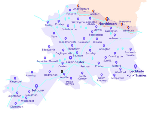
- This first map is just a guide. To view all stops, please see the list below.
- The circle symbol (Cirencester) indicates that the Robin will not complete journeys within the town (you can book to be dropped off there, coming in from outside town, or book a pick up from in town, and head out).
- All Robin areas are separate.
- Our South Cotswolds area overlaps into The Robin North (to the north), see the orange area. This is to allow residents in these overlapping areas to choose their preferred Robin service, and not designed for onward travel into a second Robin area. You should use you Robin booking to connect with a fixed line service, or get to your destination if no fixed line is available. See all fixed line services at TravelineSW.
- If hoping to travel from one Robin area into another, we would recommend against this. You would need two bookings and need to change vehicle.
Kemble Station
Please note that The Robin serves Kemble station, and so too does Wiltshire Council's "Wiltshire Connect" on-demand bus service. For more information see Wiltshire Connect homepage (click here).
Below is the full list of The Robin South Cotswolds bus stops where you can be collected or dropped off.
- For the interactive map, and to book a journey, please log into the website
- Use our App (download on Apple or Android)
- If neither of these are possible, please call our Robin team: 0345 263 8139 📱
Stop name |
Village / District |
| Nailsworth Bus Station | Interchange to/from fixed line (Outside of this Robin Area) |
| Ablington House (SE), Bibury Road, Ablington | Ablington |
| Ablington House (NW), Bibury Road, Ablington | Ablington |
| Memorial (S), The Green, Aldsworth | Aldsworth |
| Memorial (N), The Green, Aldsworth | Aldsworth |
| Blackpitts Farm Lane (S), Sherborne Road, Aldsworth | Aldsworth |
| Blackpitts Farm Lane (N), Sherborne Road, Aldsworth | Aldsworth |
| The Donkey Field (NW), Main Street, Ampney Crucis | Ampney Crucis |
| The Pleydells (NE), Village Street, Ampney Crucis | Ampney Crucis |
| The Pleydells (W), Village Street, Ampney Crucis | Ampney Crucis |
| The Old Rectory (S), Village Street, Ampney Crucis | Ampney Crucis |
| The Old Rectory (N), Village Street, Ampney Crucis | Ampney Crucis |
| Village Street (E), London Road A417, Ampney St Peter | Ampney St Peter |
| Village Street (W), London Road A417, Ampney St Peter | Ampney St Peter |
| Templefields & Crossfields (NE), Gloucester Road, Andoversford | Andoversford |
| Templefields & Crossfields (SW), Gloucester Road, Andoversford | Andoversford |
| Cattle Market (SE), Station Road, Andoversford | Andoversford |
| Cattle Market (NW), Station Road, Andoversford | Andoversford |
| Bibury Post Office (SW), B4425, Arlington | Arlington |
| Bibury Post Office (NE), B4425, Arlington | Arlington |
| Lawrence Road (SE), Hampton Hill, Avening | Avening |
| Lawrence Road (NW), Hampton Hill, Avening | Avening |
| Memorial Hall (SE), High Street, Avening | Avening |
| St Margaret's Church (NW), Main Street, Bagendon | Bagendon |
| St Margaret's Church (SE), Main Street, Bagendon | Bagendon |
| The Village Pub (NE), B4425, Barnsley | Barnsley |
| The Village Pub (SW), B4425, Barnsley | Barnsley |
| Mill (SW), Baunton | Baunton |
| Mill (NW), Cheltenham Road A435, Baunton | Baunton |
| Castle (SE), A4135, Beverston | Beverston |
| The Square (NE), B4425, Bibury | Bibury |
| The Square (SW), B4425, Bibury | Bibury |
| Aldsworth Road Estate (NE), B4425, Bibury | Bibury |
| Aldsworth Road Estate (SW), B4425, Bibury | Bibury |
| Village Stores (SE), Ermin Way, Birdlip | Birdlip |
| Village Stores (NW), Ermin Way, Birdlip | Birdlip |
| Bowling Green Lane (SE), Abbey Way, Bowling Green | Bowling Green |
| Bowling Green Lane (NW), Abbey Way, Bowling Green | Bowling Green |
| War Memorial (W), Birdlip Road, Brimpsfield | Brimpsfield |
| War Memorial (E), Birdlip Road, Brimpsfield | Brimpsfield |
| Calcot Manor Hotel (SE), A4135, Calcot | Calcot |
| Calcot Manor Hotel (NW), A4135, Calcot | Calcot |
| Manor (SW), Main Street, Calmsden | Calmsden |
| Manor (NE), Main Street, Calmsden | Calmsden |
| Compton House (opp), Cassey Compton Lane, Cassey Compton | Cassey Compton |
| Compton House (by), Cassey Compton Lane, Cassey Compton | Cassey Compton |
| The Crown (Pub) | Cerney Wick |
| Calmsden Turn (SW), Calmsden Road, Chedworth | Chedworth |
| Calmsden Turn (NE), Calmsden Road, Chedworth | Chedworth |
| The Ladder House (NW), Cheap Street, Chedworth | Chedworth |
| The Ladder House (SE), Cheap Street, Chedworth | Chedworth |
| Seven Tuns Turn (SE), Cheap Street, Chedworth | Chedworth |
| Royal Agricultural College (E), Stroud Road A419, Cirencester | Cirencester |
| Royal Agricultural College (W), Stroud Road A419, Cirencester | Cirencester |
| Tescos, Cirencester | Cirencester |
| Cirencester Hospital | Cirencester |
| DMH, Norcote Workshop | Cirencester |
| The Forum (S), Cirencester | Cirencester |
| The Forum (N), Cirencester | Cirencester |
| The Rectory (SE), Coates | Coates |
| The Rectory (NW), Coates | Coates |
| Quakers Row (SW), Coates Lane, Coates | Coates |
| Quakers Row (NE), Coates Lane, Coates | Coates |
| Withington Turn (SE), A435, Colesbourne | Colesbourne |
| Withington Turn (NW), A435, Colesbourne | Colesbourne |
| Phone Box (SW), Main Street, Coln Rogers | Coln Rogers |
| Phone Box (NE), Main Street, Coln Rogers | Coln Rogers |
| Post Office (SW), Coln St Aldwyns | Coln St Aldwyns |
| Post Office (N), Quenington Road, Coln St Aldwyns | Coln St Aldwyns |
| St James' Church (NE), Coln St Dennis | Coln St Dennis |
| St James' Church (SW), Coln St Dennis | Coln St Dennis |
| Calcot Bench (E or W) | Coln St. Dennis |
| St Oswald's Church (SE), Compton Abdale | Compton Abdale |
| St Oswald's Church (NW), Compton Abdale | Compton Abdale |
| The Old Post Office (SW), Main Street, Culkerton | Culkerton |
| The Old Post Office (NE), Main Street, Culkerton | Culkerton |
| Village Hall (W), Overley Road, Daglingworth | Daglingworth |
| Village Hall (SE), Overley Road, Daglingworth | Daglingworth |
| King's Arms (E), The Street, Didmarton | Didmarton |
| King's Arms (W), The Street, Didmarton | Didmarton |
| Highgrove Cottages (NE), Bath Road, Doughton | Doughton |
| Highgrove Cottages (SW), Bath Road, Doughton | Doughton |
| Broadleaze (S), Poulton Lane, Down Ampney | Down Ampney |
| Broadleaze (N), Poulton Lane, Down Ampney | Down Ampney |
| Driffield Phone box (N or S) | Driffield |
| St Peter's Church (SW), The Green, Duntisbourne Abbots | Duntisbourne Abbots |
| St Peter's Church (NE), The Green, Duntisbourne Abbots | Duntisbourne Abbots |
| Triangle (W), Duntisbourne Leer | Duntisbourne Leer |
| Triangle (E), Crabtree Lane, Duntisbourne Leer | Duntisbourne Leer |
| St Michael's Church (NW), Main Street, Duntisbourne Rouse | Duntisbourne Rouse |
| St Michael's Church (SE), Main Street, Duntisbourne Rouse | Duntisbourne Rouse |
| The Victoria Inn (NW), Main Street, Eastleach Turville | Eastleach Turville |
| The Victoria Inn (SE), Main Street, Eastleach Turville | Eastleach Turville |
| Westerleigh Crossroads (NE), Elkstone | Elkstone |
| Westerleigh Crossroads (SW), Elkstone | Elkstone |
| Newcombe End (S), Elkstone | Elkstone |
| Newcombe End (N), Elkstone | Elkstone |
| Poole Keynes Turn (NE), Main Street, Ewen | Ewen |
| Whelford Road Garage (NW), London Road, Fairford | Fairford |
| Whelford Road Garage (SE), London Road, Fairford | Fairford |
| Hatherop Lane (S), Hatherop Lane, Fairford | Fairford |
| Hatherop Lane (N), Hatherop Lane, Fairford | Fairford |
| Market Place (N), High Street, Fairford | Fairford |
| Market Place (S), High Street, Fairford | Fairford |
| St Peter's Church (SE), Main Street, Farmington | Farmington |
| St Peter's Church (NW), Main Street, Farmington | Farmington |
| Hare & Hounds (SW), A429 Foss Way, Foss Cross | Foss Cross |
| Hare & Hounds (NE), A429 Foss Way, Foss Cross | Foss Cross |
| The Hollies (S), Main Street, Frampton Mansell | Frampton Mansell |
| The Hollies (N), Main Street, Frampton Mansell | Frampton Mansell |
| St Luke's Church (NE), Main Street, Frampton Mansell | Frampton Mansell |
| St Luke's Church (SW), Main Street, Frampton Mansell | Frampton Mansell |
| Community Connexions Barnwood | Gloucester |
| Telephone Box (E), Main Street, Great Barrington | Great Barrington |
| Telephone Box (W), Main Street, Great Barrington | Great Barrington |
| Castle School (W), Hatherop | Hatherop |
| Castle School (E), Hatherop | Hatherop |
| St Andrew's Church (E), Church Road, Hazleton | Hazleton |
| St Andrew's Church (N), Church Road, Hazleton | Hazleton |
| Latterwood House (NE), B4058, Horsley | Horsley |
| Latterwood House (SW), B4058, Horsley | Horsley |
| Post Office (N), Windmill Road, Kemble | Kemble |
| Post Office (S), Windmill Road, Kemble | Kemble |
| Primary School (NW), School Road, Kemble | Kemble |
| Primary School (SE), School Road, Kemble | Kemble |
| Kemble Train Station | Kemblw |
| Cross Tree Crescent (NW), High Street, Kempsford | Kempsford |
| Cross Tree Crescent (SE), High Street, Kempsford | Kempsford |
| Mount Pleasant School stop (E), Kempsford | Kempsford |
| Mount Pleasant School stop (SW), Kempsford | Kempsford |
| Ham Lane (on High Street, for E or W) | Kempsford |
| Post Office (W), Windmill Lane, Kingscote | Kingscote |
| Post Office (E), Windmill Lane, Kingscote | Kingscote |
| Hunters Hall Inn Hotel | Kingscote |
| St John's Priory Park (N), Lechlade | Lechlade |
| St John's Priory Park (S), Lechlade | Lechlade |
| Londis Shop (N), Burford Street, Lechlade | Lechlade |
| Garden Centre (E), A417, Lechlade | Lechlade |
| Garden Centre (W), A417, Lechlade | Lechlade |
| St Andrew's Church (S), The Street, Leighterton | Leighterton |
| St Andrew's Church (N), The Street, Leighterton | Leighterton |
| The Inn For All Seasons (E), A40, Little Barrington | Little Barrington |
| The Inn For All Seasons (W), A40, Little Barrington | Little Barrington |
| Phone Box (S), Main Street, Little Barrington | Little Barrington |
| Phone Box (N), Main Street, Little Barrington | Little Barrington |
| Church Lane (SE), Tetbury Road B4014, Long Newnton | Long Newnton |
| Church Lane (NW), Tetbury Road B4014, Long Newnton | Long Newnton |
| War Memorial (SW), Hensons Hill, Lower Chedworth | Lower Chedworth |
| War Memorial (NE), Hensons Hill, Lower Chedworth | Lower Chedworth |
| High Street (W), A417, Meysey Hampton | Meysey Hampton |
| High Street (E), A417, Meysey Hampton | Meysey Hampton |
| Greenacres Park (E), Meysey Hampton | Meysey Hampton |
| Greenacres Park (W), A417, Meysey Hampton | Meysey Hampton |
| ERROR School Lane (S) | Meysey Hampton |
| School Lane (N) | Meysey Hampton |
| The Masons Arms (SW) | Meysey Hampton |
| The Masons Arms (NE) | Meysey Hampton |
| Nailsworth Garden Centre | Nailsworth |
| Churnside | North Cerney |
| Phone Box | North Cerney |
| The Old Police Station (NE), A429 Fosse Way, Northleach | Northleach |
| The Old Police Station (SW), A429 Fosse Way, Northleach | Northleach |
| Nostle Road (SW), East End, Northleach | Northleach |
| Nostle Road (NE), Northleach | Northleach |
| Market Place (NW), Market Place, Northleach | Northleach |
| Woodchester Park, Tinkley Gate | Nympsfield |
| The Malt House (NW), Cutham Lane, Perrotts Brook | Perrotts Brook |
| The Malt House (SE), Cutham Lane, Perrotts Brook | Perrotts Brook |
| The Cross (SE), Main Street, Poole Keynes | Poole Keynes |
| The Falcon (SW), Cricklade Street, Poulton | Poulton |
| The Falcon (NE), Cricklade Street, Poulton | Poulton |
| Kingsway (SW), Wilpit Lane, Preston | Preston |
| Kingsway (NE), Wilpit Lane, Preston | Preston |
| Village Hall (SW), Wilpit Lane, Preston | Preston |
| Village Hall (NE), Wilpit Lane, Preston | Preston |
| The Green (N), Springfield Road, Quenington | Quenington |
| The Green (S), Quenington | Quenington |
| Coneygar Road (N), Quenington | Quenington |
| Coneygar Road (S), Springfield Road, Quenington | Quenington |
| Rendcomb Turn (NW), Cheltenham Road, Rendcomb | Rendcomb |
| Rendcomb Turn (SE), Cheltenham Road, Rendcomb | Rendcomb |
| St Peter's Church (NE), Main Street, Rodmarton | Rodmarton |
| St Peter's Church (SW), Main Street, Rodmarton | Rodmarton |
| The Glebe (SE), Daneway Lane, Sapperton | Sapperton |
| The Glebe (NW), Daneway Lane, Sapperton | Sapperton |
| Sapperton School (NE), Main Street, Sapperton | Sapperton |
| Sapperton School (SW), Main Street, Sapperton | Sapperton |
| Hungry Horse (SW), Gloucester Road A436, Seven Springs | Seven Springs |
| Hungry Horse (NE), Gloucester Road A436, Seven Springs | Seven Springs |
| St Mary's Church (NW), Main Street, Sherborne | Sherborne |
| St Mary's Church (SE), Main Street, Sherborne | Sherborne |
| Sherborne (Sherborne Turn) (E) | Sherborne |
| Sherborne (Sherborne Turn) (W) | Sherborne |
| Pond Farm (W), Hedgeditch Lane, Shipton Moyne | Shipton Moyne |
| Pond Farm (E), Hedgeditch Lane, Shipton Moyne | Shipton Moyne |
| Post Office (SE), Shipton Moyne | Shipton Moyne |
| Post Office (NW), Shipton Moyne | Shipton Moyne |
| The Yewtrees (SW), Shipton Road, Shipton Oliffe | Shipton Oliffe |
| The Yewtrees (NE), Shipton Road, Shipton Oliffe | Shipton Oliffe |
| Frogmill Inn (E), Shipton Oliffe | Shipton Oliffe |
| Frogmill Inn (W), Shipton Oliffe | Shipton Oliffe |
| Wyatt Court (NE), Shipton Road, Shipton Oliffe | Shipton Oliffe |
| Wyatt Court (SW), Shipton Road, Shipton Oliffe | Shipton Oliffe |
| Nursery View (S), Ashton Road, Siddington | Siddington |
| Nursery View (N), Ashton Road, Siddington | Siddington |
| Post Office (NE), Ashton Road, Siddington | Siddington |
| Post Office (SW), Ashton Road, Siddington | Siddington |
| Village Hall (N), Ashton Road, Siddington | Siddington |
| Village Hall (S), Ashton Road, Siddington | Siddington |
| Dobbies Garden Centre | Siddington |
| Mill Lane (SW), Main Street, Somerford Keynes | Somerford Keynes |
| Mill Lane (NE), Main Street, Somerford Keynes | Somerford Keynes |
| Old School Cottages (S), Main Street, Somerford Keynes | Somerford Keynes |
| Old School Cottages (N), Main Street, Somerford Keynes | Somerford Keynes |
| The Watermark Spring Lake (SE), Station Road, South Cerney | South Cerney |
| The Watermark Spring Lake (NW), Station Road, South Cerney | South Cerney |
| Royal Oak (W), High Street, South Cerney | South Cerney |
| Royal Oak (E), High Street, South Cerney | South Cerney |
| The Lennards (W), Station Road, South Cerney | South Cerney |
| The Lennards (E), Station Road, South Cerney | South Cerney |
| Southrop School (E), Main Street, Southrop | Southrop |
| Southrop School (W), Main Street, Southrop | Southrop |
| Quarry View (N), Lechlade Road, Southrop | Southrop |
| Quarry View (S), Lechlade Road, Southrop | Southrop |
| The Swan (NE), Main Road, Southrop | Southrop |
| The Swan (SW), Main Road, Southrop | Southrop |
| The Swan (NE) | Southrop |
| Vaisey Road (W), Haresfield, Stratton | Stratton |
| Park View (N), Stratton Heights, Stratton | Stratton |
| Overhill Road (W), Overhill Road, Stratton | Stratton |
| Crossroads (W), The Green, Tarlton | Tarlton |
| Crossroads (SE), The Green, Tarlton | Tarlton |
| Springfields (NE), Cirencester Road, Tetbury | Tetbury |
| Tesco (SW), London Road, Tetbury | Tetbury |
| The Old School Court (W), Charlton Road, Tetbury | Tetbury |
| The Old School Court (E), Charlton Road, Tetbury | Tetbury |
| Bank (NW), Long Street, Tetbury | Tetbury |
| The Ormond at Tetbury (SE), Long Street, Tetbury | Tetbury |
| Tesco (NE), London Road, Tetbury | Tetbury |
| Knockdown (The Holford Arms) | Tetbury |
| Churchill Road (W), London Road, The Beeches | The Beeches |
| Churchill Road (E), London Road, The Beeches | The Beeches |
| All Saints' Church (SW), Main Street, Turkdean | Turkdean |
| All Saints' Church (NE), Turkdean | Turkdean |
| Westonbirt Arboretum (S), A433 Bath Road, Westonbirt | Westonbirt |
| Westonbirt Arboretum (N), A433 Bath Road, Westonbirt | Westonbirt |
| Hare and Hounds Hotel (SW), Bath Road, Westonbirt | Westonbirt |
| Hare and Hounds Hotel (NE), Bath Road, Westonbirt | Westonbirt |
| Pope's Court (NE), Kempsford Road, Whelford | Whelford |
| Pope's Court (SW), Kempsford Road, Whelford | Whelford |
| Whittington Turn (W), A40, Whittington | Whittington |
| Whittington Turn (E), A40, Whittington | Whittington |
| Village Hall (SE), Sherborne Road, Windrush | Windrush |
| Village Hall (NW), Sherborne Road, Windrush | Windrush |
| Mill Farm (SW), Main Street, Winson | Winson |
| Mill Farm (NE), Main Street, Winson | Winson |
| Foss Field, Winstone | Winstone |
| Compton Rise (NE), Compton Abdale Lane, Withington | Withington |
| Compton Rise (SW), Compton Abdale Lane, Withington | Withington |
| The Mill Inn (E), Mill Lane, Withington | Withington |
| The Mill Inn (W), Mill Lane, Withington | Withington |
| Telephone Box (SE), Burcombe Lane, Woodmancote | Woodmancote |
| Telephone Box (NW), Burcombe Lane, Woodmancote | Woodmancote |
| The Apiary (NE), Woodmancote | Woodmancote |
| The Apiary (SW), Woodmancote | Woodmancote |
| St Michael's Church (E), Church Lane, Yanworth | Yanworth |
| Village Hall (SW), Main Street, Yanworth | Yanworth |
| Village Hall (NE), Main Street, Yanworth | Yanworth |
As mentioned above, no journeys can be booked wholly within Cirencester. This is because walking routes and fixed line bus services are already available.
Last reviewed: