Forest of Dean South
South Forest of Dean
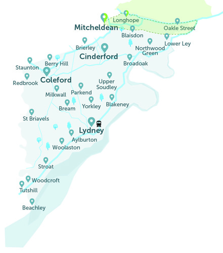
- Our South Forest of Dean area overlaps into The Robin Newent Zone (to the north), see the area inside the dotted line. This is to allow residents in these overlapping areas to choose their preferred Robin service, and not designed for onward travel into a second Robin area.
- Mitcheldean and Longhope are Robin stops for both the Newent Zone and for the South Forest of Dean Robin areas. This is so people can get to these locations from the north or from the south.
Any out of district (and out of county) bus stops being used are drop off only. You can't get picked up outside the Forest of Dean.
The map above is just a guide.
To view all stops, please see below.
Below is the full list of bus stops where you can be collected or dropped off, within the southern Forest of Dean area of The Robin.
- For the interactive map, and to book a journey, please log into the website
- Use our App (download on Apple or Android)
- If neither of these are possible, please call our Robin team: 0345 263 8139 📱
Stop name |
District / Village (A to Z) |
| Adsett Court (nr), Adsett Lane, Adsett | Adsett |
| Adsett Court (opp), Adsett Lane, Adsett | Adsett |
| The Old Chapel (nr), Hunt Hill, Adsett | Adsett |
| The Old Chapel (opp), Hunt Hill, Adsett | Adsett |
| Driffield Road (nr), Allaston | Allaston |
| Driffield Road (opp), Allaston | Allaston |
| Grove Lane (nr), Allaston | Allaston |
| Grove Lane (opp), Allaston | Allaston |
| Severn Heights (nr), Allaston | Allaston |
| Severn Heights (opp), Allaston | Allaston |
| Soilwell Farm (o/s), Yorkley Lane, Allaston | Allaston |
| Soilwell Farm (opp), Allaston | Allaston |
| Globe Inn (nr), Main Road A48, Alvington | Alvington |
| Globe Inn (opp), Main Road A48, Alvington | Alvington |
| Common Turn (corner of), A48, Aylburton | Aylburton |
| Common Turn (opp), A48, Aylburton | Aylburton |
| Millbrook Green (corner of), High St A48, Aylburton | Aylburton |
| Millbrook Green (opp), High St A48, Aylburton | Aylburton |
| Stockwell Lane (before), Aylburton | Aylburton |
| Stockwell Lane (opp), Aylburton | Aylburton |
| Barracks Families Office (o/s), Pavilion Road, Beachley | Beachley |
| Barracks Main Gate (o/s), Beachley Road, Beachley | Beachley |
| Barracks Main Gate (opp), Beachley Road, Beachley | Beachley |
| Beachley Gate (o/s), Beachley Road, Beachley | Beachley |
| Beachley Gate (opp), Beachley Road, Beachley | Beachley |
| Families Office (nr), Pavilion Road, Beachley | Beachley |
| Gibraltar Way East (on), Gibraltar Way, Beachley | Beachley |
| Gibraltar Way West (on), Gibraltar Way, Beachley | Beachley |
| Loop Road (by), Beachley | Beachley |
| Pavilion Road (corner of), Beachley | Beachley |
| Pavilion Road (opp), Beachley | Beachley |
| Post Office (by), Loop Road, Beachley | Beachley |
| Severn Bridge Park (corner of), Beachley Road, Beachley | Beachley |
| Three Salmon House (by), Beachley Road, Beachley | Beachley |
| Forest Patch (before), Grove Road, Berry Hill | Berry Hill |
| Globe Inn (o/s), Park Road, Berry Hill | Berry Hill |
| Globe Inn (opp), Park Road, Berry Hill | Berry Hill |
| Highfield (by), Berry Hill | Berry Hill |
| Highfield (on), Berry Hill | Berry Hill |
| King's Head (o/s), Grove Road, Berry Hill | Berry Hill |
| King's Head (opp), Grove Road, Berry Hill | Berry Hill |
| Lakers Road (before), Berry Hill | Berry Hill |
| Lakers Road (opp), Berry Hill | Berry Hill |
| Marians Walk (before), Grove Road, Berry Hill | Berry Hill |
| Petrol Station (by), Lower Road, Berry Hill | Berry Hill |
| Petrol Station (nr), Lower Road, Berry Hill | Berry Hill |
| Pikehouse (by), Grove Road, Berry Hill | Berry Hill |
| Pikehouse (nr), Grove Road, Berry Hill | Berry Hill |
| The Pikehouse (after), Lower Lane, Berry Hill | Berry Hill |
| The Pikehouse (before), Lower Lane A4136, Berry Hill | Berry Hill |
| Stowe Road (corner of), Bigsweir | Bigsweir |
| Stowe Road (opp), Bigsweir | Bigsweir |
| The Florence Hotel (before), Lower Wye Valley Road A466, Bigsweir | Bigsweir |
| The Florence Hotel (opp), Lower Wye Valley Road A466, Bigsweir | Bigsweir |
| Wyeseal Farm (by), Lower Wye Valley Road A466, Bigsweir | Bigsweir |
| Wyeseal Farm (opp), Lower Wye Valley Road A466, Bigsweir | Bigsweir |
| Boseley Court School Stop (by), Blaisdon | Blaisdon |
| Boseley Court School Stop (nr), Blaisdon | Blaisdon |
| Monk Hill Farm (by), Blaisdon | Blaisdon |
| Monk Hill Farm (opp), Blaisdon | Blaisdon |
| The Red Hart Inn (before), Main Street, Blaisdon | Blaisdon |
| The Red Hart Inn (opp), Main Street, Blaisdon | Blaisdon |
| War Memorial (nr), Main Street, Blaisdon | Blaisdon |
| Highfield (by), Cinderford Road, Blakeney | Blakeney |
| Highfield (opp), Cinderford Road, Blakeney | Blakeney |
| Hitchings (after), Cinderford Road, Blakeney | Blakeney |
| Hitchings (opp), Cinderford Road, Blakeney | Blakeney |
| King's Head (o/s), High Street, Blakeney | Blakeney |
| King's Head (opp), High Street, Blakeney | Blakeney |
| Kingsland (by), A48, Blakeney | Blakeney |
| Kingsland (opp), A48, Blakeney | Blakeney |
| New Road (corner of), Blakeney | Blakeney |
| New Road (opp), Blakeney | Blakeney |
| Orchard Gate (corner of), Cinderford Road, Blakeney | Blakeney |
| Orchard Gate (opp), Cinderford Road, Blakeney | Blakeney |
| Severn View Garden Centre (by), A48, Blakeney | Blakeney |
| Severn View Garden Centre (opp), A48, Blakeney | Blakeney |
| Underdean House (by), A48, Blakeney | Blakeney |
| Underdean House (opp), A48, Blakeney | Blakeney |
| Viney Hill Turn (after), A48, Blakeney | Blakeney |
| Viney Hill Turn (before), Blakeney | Blakeney |
| Forest Patch (on), Cinderford Road, Bradley Hill | Bradley Hill |
| Forest Patch (opp), Cinderford Road, Bradley Hill | Bradley Hill |
| Ayleford Turn (by), Cinderford Road, Brain's Green | Brain's Green |
| Ayleford Turn (opp), Cinderford Road, Brain's Green | Brain's Green |
| Triangle (by), Cinderford Road, Brain's Green | Brain's Green |
| Triangle (on), Cinderford Road, Brain's Green | Brain's Green |
| Bowson Road Junction (after), Bream | Bream |
| Bowson Road Junction (opp), Bream | Bream |
| Bowson Square (corner of), Parkend Road, Bream | Bream |
| Bowson Square (opp), Parkend Road, Bream | Bream |
| Bungalows (by), Bowson Road, Bream | Bream |
| Bungalows (opp), Bowson Road, Bream | Bream |
| Community Centre (nr), High Street, Bream | Bream |
| Community Centre (opp), High Street, Bream | Bream |
| Court Farm (o/s), Coleford Road, Bream | Bream |
| Court Farm (opp), Coleford Road, Bream | Bream |
| Elmsleigh (by), Bowson Road, Bream | Bream |
| Elmsleigh (opp), Bowson Road, Bream | Bream |
| Hang Hill Road (nr), Bream | Bream |
| Hang Hill Road (opp), Bream | Bream |
| Maypole House (nr), High Street, Bream | Bream |
| Maypole House (opp), High Street, Bream | Bream |
| Maypole Road (corner of), Bream | Bream |
| Maypole Road (opp), Bream | Bream |
| New Road (corner of), Bream | Bream |
| New Road (opp), Bream | Bream |
| Oakwood Mill (o/s), Main Road, Bream | Bream |
| Oakwood Mill (opp), Main Road, Bream | Bream |
| Rugby Club (by), High Street, Bream | Bream |
| Rugby Club (nr), High Street, Bream | Bream |
| School (o/s), Main Road, Bream | Bream |
| School (opp), Main Road, Bream | Bream |
| St James Church (by), Coleford Road, Bream | Bream |
| St James Church (opp), Coleford Road, Bream | Bream |
| Sun Rise Road (corner of), Bream | Bream |
| Sun Rise Road (opp), Bream | Bream |
| The Keys (nr), Whitecroft Road, Bream | Bream |
| The Keys (opp), Whitecroft Road, Bream | Bream |
| Service Station (by), High Street, Brierley | Brierley |
| Swan Inn (by), Brierley Banks, Brierley | Brierley |
| Swan Inn (o/s), High Street, Brierley | Brierley |
| Swan Inn (opp), High Street, Brierley | Brierley |
| The Delves (by), A4136, Brierley | Brierley |
| The Delves (nr), A4136, Brierley | Brierley |
| Glevum (by), A48, Broadoak | Broadoak |
| Glevum (opp), A48, Broadoak | Broadoak |
| Silver Fox Cafe (after), A48, Broadoak | Broadoak |
| Silver Fox Cafe (opp), A48, Broadoak | Broadoak |
| The White Hart (after), A48, Broadoak | Broadoak |
| The White Hart (by), A48, Broadoak | Broadoak |
| Bird-in-hand (before), North Road, Broadwell | Broadwell |
| Bird-in-hand (opp), North Road, Broadwell | Broadwell |
| Bridge (after), South Road, Broadwell | Broadwell |
| Bridge (before), South Road, Broadwell | Broadwell |
| Church Walk (after), North Road, Broadwell | Broadwell |
| Football Ground (by), South Road, Broadwell | Broadwell |
| Football Ground (nr), South Road, Broadwell | Broadwell |
| Memorial Hall (o/s), North Road, Broadwell | Broadwell |
| Queensway (by), South Road, Broadwell | Broadwell |
| Queensway (nr), South Road, Broadwell | Broadwell |
| Bullo Cross (by), A48, Bullo | Bullo |
| Bullo Cross (nr), A48, Bullo | Bullo |
| The Old Barn (by), A48, Bullo | Bullo |
| The Old Barn (opp), A48, Bullo | Bullo |
| Grange Village (Camphill Village Trust), Littledean | Camphill Village Trust |
| Beechenhurst Lodge Gate (by), Speech House Road, Cannop | Cannop |
| Beechenhurst Lodge Gate (opp), Speech House Road, Cannop | Cannop |
| Hopewell Colliery (o/s), Speech House Road, Cannop | Cannop |
| Hopewell Colliery (opp), Speech House Road, Cannop | Cannop |
| Pygmy Pinetum (after), Speech House Road, Cannop | Cannop |
| Pygmy Pinetum (before), Speech House Road, Cannop | Cannop |
| Speech House (by), Parkend Road, Cannop | Cannop |
| Speech House (o/s), Speech House Road B4226, Cannop | Cannop |
| Speech House (opp), Speech House Road B4226, Cannop | Cannop |
| Garage (before), A48, Chaxhill | Chaxhill |
| Garage (opp), A48, Chaxhill | Chaxhill |
| Hunt Hill Turn (just after), A48 Hunt Hill, Chaxhill | Chaxhill |
| Hunt Hill Turn (opp), A48 Hunt Hill, Chaxhill | Chaxhill |
| Bridewell Farm (by), Woodland Road, Christchurch | Christchurch |
| Bridewell Farm (opp), Woodland Road, Christchurch | Christchurch |
| Church (by), Ross Road, Christchurch | Christchurch |
| Church (opp), Ross Road, Christchurch | Christchurch |
| Crossroads (by), Park Road, Christchurch | Christchurch |
| Crossroads (nr), Park Road, Christchurch | Christchurch |
| Woodland Road (in), Christchurch | Christchurch |
| Woodland Road (on), Christchurch | Christchurch |
| Bulley Lane Turn (after), Churcham | Churcham |
| Bulley Lane Turn (opp), Churcham | Churcham |
| Business Park (after), A40, Churcham | Churcham |
| Business Park (opp), A40, Churcham | Churcham |
| Petol Station (by), Churcham | Churcham |
| Petrol Station (opp), A40, Churcham | Churcham |
| Abbots Road (after), Cinderford | Cinderford |
| Abbots Road (corner of), Cinderford | Cinderford |
| Abbots Road (on), Cinderford | Cinderford |
| Abbotswood Garage (after), High Street, Cinderford | Cinderford |
| Abbotswood Garage (opp), High Street, Cinderford | Cinderford |
| Baptist Church (opp), Commercial Street, Cinderford | Cinderford |
| Beechdean (by), Station Terrace, Cinderford | Cinderford |
| Beechdean (opp), Station Terrace, Cinderford | Cinderford |
| Bristol House Store (o/s), Church Road, Cinderford | Cinderford |
| Bristol House Store (opp), Church Road, Cinderford | Cinderford |
| Brook (by), Valley Road, Cinderford | Cinderford |
| Brook (opp), Valley Road, Cinderford | Cinderford |
| College Road (opp), Cinderford | Cinderford |
| Co-op Store (before), Valley Road, Cinderford | Cinderford |
| Co-op Store (opp), Valley Road, Cinderford | Cinderford |
| Co-op Superstore (o/s), Cinderford | Cinderford |
| Crabtree Road (by), Cinderford | Cinderford |
| Crawshay Place (by), Hastings Road, Cinderford | Cinderford |
| Crawshay Place (opp), Hastings Road, Cinderford | Cinderford |
| Dilke Hospital (o/s), Speech House Road, Cinderford | Cinderford |
| Dilke Hospital (opp), Speech House Road, Cinderford | Cinderford |
| Dockham Road (after), Cinderford | Cinderford |
| Dockham Road (opp), Cinderford | Cinderford |
| Electric Sub Station (by), York Road, Cinderford | Cinderford |
| Electric Sub Station (nr), York Road, Cinderford | Cinderford |
| Fairfields (after), Hastings Road, Cinderford | Cinderford |
| Fairfields (before), Hastings Road, Cinderford | Cinderford |
| Flaxley Street (before), Cinderford | Cinderford |
| Flaxley Street (corner of), Cinderford | Cinderford |
| Forest View Park (o/s), Valley Road, Cinderford | Cinderford |
| Forest View Park (opp), Valley Road, Cinderford | Cinderford |
| Forge Hammer Inn (by), Victoria Street, Cinderford | Cinderford |
| Forge Hammer Inn (opp), Victoria Street, Cinderford | Cinderford |
| Greenway Road (opp), Cinderford | Cinderford |
| Hart Green (by), Ruspidge Road, Cinderford | Cinderford |
| Hart Green (opp), Ruspidge Road, Cinderford | Cinderford |
| Hastings Road (corner of), Cinderford | Cinderford |
| Hastings Road (nr), Cinderford | Cinderford |
| Hastings Road (opp), Cinderford | Cinderford |
| Highview Road (after), Cinderford | Cinderford |
| Highview Road (before), Cinderford | Cinderford |
| Hollywood Works (by), Valley Road, Cinderford | Cinderford |
| Hollywood Works (nr), Valley Road, Cinderford | Cinderford |
| Industrial Estate (after), Steam Mills Road, Cinderford | Cinderford |
| Industrial Estate (before), Steam Mills Road, Cinderford | Cinderford |
| Kensley Vale (opp), Albert Road, Cinderford | Cinderford |
| Library (by), Belle Vue Road, Cinderford | Cinderford |
| Library (opp), Belle Vue Road, Cinderford | Cinderford |
| Lidl Store (o/s), High Street, Cinderford | Cinderford |
| Lidl Store (opp), High Street, Cinderford | Cinderford |
| Meendhurst Road (opp), Cinderford | Cinderford |
| Mount Pleasant (after), St White's Road, Cinderford | Cinderford |
| Mount Pleasant (opp), St White's Road, Cinderford | Cinderford |
| Parragate Road (after), Cinderford | Cinderford |
| Parragate Road (opp), Cinderford | Cinderford |
| Railway Road (after), Cinderford | Cinderford |
| Railway Road (opp), Cinderford | Cinderford |
| Rowandean Court (by), Elmdene, Cinderford | Cinderford |
| Rowandean Court (opp), Elmdene, Cinderford | Cinderford |
| Severn View (by), Latimer Road, Cinderford | Cinderford |
| Severn View (opp), Latimer Road, Cinderford | Cinderford |
| Somerset Road (by), Cinderford | Cinderford |
| Somerset Road (opp), Cinderford | Cinderford |
| St Stephen's Church (nr), Belle Vue Road, Cinderford | Cinderford |
| St Stephen's Church (opp), Belle Vue Road, Cinderford | Cinderford |
| St White's Primary School (by), Buckshaft Road, Cinderford | Cinderford |
| St White's Primary School (opp), Buckshaft Road, Cinderford | Cinderford |
| Station Street (after), Cinderford | Cinderford |
| Station Street (nr), Cinderford | Cinderford |
| Stockwell Green (before), Church Road, Cinderford | Cinderford |
| Stockwell Green (opp), Church Road, Cinderford | Cinderford |
| The Forest High School (o/s), Causeway Road, Cinderford | Cinderford |
| The Forest High School (opp), Cinderford | Cinderford |
| The Keelings (after), Station Street, Cinderford | Cinderford |
| The Keelings (by), Station Street, Cinderford | Cinderford |
| The Oak Field (after), Cinderford | Cinderford |
| The Oak Field (opp), Littledean Hill Road, Cinderford | Cinderford |
| The Royal Foresters (by), Causeway Road, Cinderford | Cinderford |
| The Royal Foresters (opp), Causeway Road, Cinderford | Cinderford |
| The Woodlands (after), St White's Road, Cinderford | Cinderford |
| The Woodlands (before), St White's Road, Cinderford | Cinderford |
| Triangle DIY Shop (nr), Market Street, Cinderford | Cinderford |
| Triangle HSBC Bank (by), Cinderford | Cinderford |
| Triangle school stop (opp), Cinderford | Cinderford |
| Upper Bilson Inn (nr), Valley Road, Cinderford | Cinderford |
| Valley Road (after), Cinderford | Cinderford |
| Valley Road (corner of), Hospital Cinderford | Cinderford |
| Victoria Street (by), Cinderford | Cinderford |
| Victoria Street (opp), Cinderford | Cinderford |
| Whimsey Road (by), Cinderford | Cinderford |
| White Hart (by), St White's Road, Cinderford | Cinderford |
| White Hart (opp), St White's Road, Cinderford | Cinderford |
| Why Not (nr), Somerset Road, Cinderford | Cinderford |
| Worcester Road (after), Cinderford | Cinderford |
| Worcester Road (opp), Cinderford | Cinderford |
| Yew Tree Brake Cemetery (nr), Speech House Road, Cinderford | Cinderford |
| Yew Tree Brake Cemetery (opp), Speech House Road, Cinderford | Cinderford |
| Mallards Pike | Cinderford |
| Forest of Dean Community Hospital | Cinderford |
| Butchers Arms (by), High Street, Clearwell | Clearwell |
| Butchers Arms (opp), High Street, Clearwell | Clearwell |
| Clearwell Caves (opp), Lambsquay Road, Clearwell | Clearwell |
| Council Villas (by), Clearwell Road, Clearwell | Clearwell |
| Council Villas (opp), Clearwell Road, Clearwell | Clearwell |
| Margery Lane (corner of), Clearwell | Clearwell |
| Margery Lane (opp), Clearwell | Clearwell |
| St Peter's Church (before), Church Street, Clearwell | Clearwell |
| St Peter's Church (by), Church Street, Clearwell | Clearwell |
| Tannery Gardens (o/s), Newland Road, Clearwell | Clearwell |
| Tannery Gardens (opp), Newland Road, Clearwell | Clearwell |
| The Rocks (by), High Street, Clearwell | Clearwell |
| The Rocks (opp), High Street, Clearwell | Clearwell |
| Bronllys (nr), Main Road, Clements End | Clements End |
| Bronllys (opp), Main Road, Clements End | Clements End |
| Elwall Farm Turn (on), Main Road, Clements End | Clements End |
| Elwall Farm Turn (opp), Main Road, Clements End | Clements End |
| Eskimarket (o/s), New Road, Coalway | Coalway |
| Eskimarket (opp), New Road, Coalway | Coalway |
| Gibsons (o/s), Edenwall Road, Coalway | Coalway |
| Gibsons (opp), Edenwall Road, Coalway | Coalway |
| Junior School (o/s), Coalway Road, Coalway | Coalway |
| Junior School (opp), Coalway Road, Coalway | Coalway |
| Angel Hotel (Stop 1), Square, Coleford | Coleford |
| Angel Hotel (Stop 2), Square, Coleford | Coleford |
| Bakers Hill (nr), B4028, Coleford | Coleford |
| Bank House (o/s), Coleford | Coleford |
| Bells Club and Hotel (by), Coleford | Coleford |
| Bells Club and Hotel (opp), Coleford | Coleford |
| Council Offices (nr), High Street, Coleford | Coleford |
| Dora Matthews House (opp), Bank Street, Coleford | Coleford |
| Fire Station (after), Cinder Hill, Coleford | Coleford |
| Fire Station (opp), Cinder Hill, Coleford | Coleford |
| Foot of Bakers Hill (before), Gloucester Road B4028, Coleford | Coleford |
| Lark Rise (after), The Gorse, Coleford | Coleford |
| Lark Rise (before), The Gorse, Coleford | Coleford |
| Old Vicarage Court (by), Lords Hill, Coleford | Coleford |
| Old Vicarage Court (opp), Lord's Hill, Coleford | Coleford |
| Police Station (by), Lord's Hill, Coleford | Coleford |
| Police Station (opp), Lord's Hill, Coleford | Coleford |
| Sunnybank (by), The Gorse, Coleford | Coleford |
| Sunnybank (opp), The Gorse, Coleford | Coleford |
| The Alms (o/s), The Gorse, Coleford | Coleford |
| The Alms (opp), The Gorse, Coleford | Coleford |
| The Coombs (after), The Gorse, Coleford | Coleford |
| The Coombs (before), The Gorse, Coleford | Coleford |
| The Crescent (after), Gloucester Road, Coleford | Coleford |
| The Crescent (opp), Gloucester Road, Coleford | Coleford |
| The Mount (twrd N) | Coleford |
| The Mount (twrd S) | Coleford |
| Perrygrove Railway Adventure | Coleford |
| Blakes Way (by), Staunton Road, Crossways | Crossways |
| Blakes Way (opp), Staunton Road, Crossways | Crossways |
| Greenmoors (o/s), Staunton Road B4228, Crossways | Crossways |
| Greenmoors (opp), Staunton Road B4228, Crossways | Crossways |
| Hearts of Oak, Drybrook Road | Drybrook |
| Hearts of Oak (Opp), Drybrook Road | Drybrook |
| West Avenue (Opp), High Street, Drybrook | Drybrook |
| West Avenue, High Street, Drybrook | Drybrook |
| Mannings Road (W) | Drybrook |
| Mannings Road (E) | Drybrook |
| May Hill Turn (corner of), A40, Dursley Cross | Dursley Cross |
| May Hill Turn (opp), A40, Dursley Cross | Dursley Cross |
| Council Villas (by), Monmouth Road, Edge End | Edge End |
| Council Villas (nr), Monmouth Road, Edge End | Edge End |
| High Beeches Avenue (in), Edge End | Edge End |
| High Beeches Avenue (on), Edge End | Edge End |
| Ellwood Cross (after), Ellwood Road, Ellwood | Ellwood |
| Ellwood Cross (before), Ellwood Road, Ellwood | Ellwood |
| Ellwood Cross (by), Clements End Road, Ellwood | Ellwood |
| Ellwood Cross (nr), Clements End Road, Ellwood | Ellwood |
| Cowle's Farm (by), Elton | Elton |
| Cowle's Farm (nr), Elton Road, Elton | Elton |
| Elton Corner (before), Elton Road A4151, Elton | Elton |
| Elton Corner (nr), Elton Road A4151, Elton | Elton |
| Elton Farm (nr), Elton Road, Elton | Elton |
| Elton Farm (opp), Elton Road, Elton | Elton |
| Garage (after), A48, Elton | Elton |
| Garage (opp), A48, Elton | Elton |
| Jordan Hill (by), A48, Elton | Elton |
| Jordan Hill (on), A48, Elton | Elton |
| Wyncoll's Turn (corner of), Elton Road, Elton | Elton |
| Wyncoll's Turn (opp), Elton Road, Elton | Elton |
| Smithy Close (S) | English Bicknor |
| Smithy Close (N) | English Bicknor |
| Smiths Hill (by), Fetter Hill | Fetter Hill |
| Smiths Hill (opp), Fetter Hill | Fetter Hill |
| Gamekeepers Inn (nr), Hillcrest Road, Five Acres | Five Acres |
| Gamekeepers Inn (o/s), Lower Lane A4136, Five Acres | Five Acres |
| Gamekeepers Inn (opp), Lower Lane A4136, Five Acres | Five Acres |
| Garage (o/s), Woodgate Road, Five Acres | Five Acres |
| Garage (opp), Woodgate Road, Five Acres | Five Acres |
| Glencarn Place (o/s), Park Road, Five Acres | Five Acres |
| Glencarn Place (opp), Park Road, Five Acres | Five Acres |
| High School (inside), Five Acres | Five Acres |
| Royal Forest of Dean College (o/s), Monmouth Road, Five Acres | Five Acres |
| Royal Forest of Dean College (opp), Monmouth Road, Five Acres | Five Acres |
| Blaisdon Turn (by), Welshbury Road, Flaxley | Flaxley |
| Blaisdon Turn (opp), Welshbury Road, Flaxley | Flaxley |
| St Mary's Church (by), Welshbury Road, Flaxley | Flaxley |
| St Mary's Church (opp), Welshbury Road, Flaxley | Flaxley |
| The Forge (nr), Main Street, Flaxley | Flaxley |
| The Forge (opp), Main Lane, Flaxley | Flaxley |
| Village Hall (by), Flaxley | Flaxley |
| Village Hall (opp), Flaxley | Flaxley |
| Broken Cross (by), Ley Court Road, Grange Court | Grange Court |
| Junction Inn (by), Grange Court Road, Grange Court | Grange Court |
| Junction Inn (opp), Grange Court Road, Grange Court | Grange Court |
| The Grange (o/s), Northwood Green Road, Grange Court | Grange Court |
| The Grange (opp), Northwood Green Road, Grange Court | Grange Court |
| Edgehills Plantation (by), Green Bottom | Green Bottom |
| Edgehills Plantation (nr), Green Bottom | Green Bottom |
| Holy Trinity Church (o/s), A4136, Harrow Hill | Harrow Hill |
| Holy Trinity Church (opp), Nailbridge Junction, Harrow Hill | Harrow Hill |
| Cottages (nr), A4136, Hawkwell | Hawkwell |
| Cottages (opp), A4136, Hawkwell | Hawkwell |
| Northern United Works (nr), A4136, Hawkwell | Hawkwell |
| Northern United Works (opp), A4136, Hawkwell | Hawkwell |
| Hewelsfield Cross (by), B4228, Hewelsfield | Hewelsfield |
| Hewelsfield Cross South (nr), B4228, Hewelsfield | Hewelsfield |
| Mushet Place (before), High Nash, High Nash | High Nash |
| Mushet Place (opp), High Nash, High Nash | High Nash |
| Rock Lane (by), High Nash | High Nash |
| Rock Lane (nr), High Nash | High Nash |
| Byfords Close (corner of), Byfords Road, Huntley | Huntley |
| Byfords Close (opp), Byfords Road, Huntley | Huntley |
| Newent Lane (before), Huntley | Huntley |
| Newent Lane (by), Huntley | Huntley |
| Oak Way (on), Byfords Road, Huntley | Huntley |
| Oak Way (opp), Byfords Road, Huntley | Huntley |
| Sawmill (o/s), Longhope Road A4136, Huntley | Huntley |
| Sawmill (opp), Huntley | Huntley |
| St John the Baptist Church (by), Ross Road A40, Huntley | Huntley |
| St John the Baptist Church (opp), Ross Road A40, Huntley | Huntley |
| Village Hall (opp), North Road, Huntley | Huntley |
| Forge Hill turn, Joy's Green | Joy's Green |
| Rocks Road, Joy's Green | Joy's Green |
| Blaisdon Turn (corner of), Little London | Little London |
| Blaisdon Turn (opp), A4136, Little London | Little London |
| Chapel Lane (before), Little London | Little London |
| Chapel Lane (nr), Little London | Little London |
| Hillview (by), A4136, Little London | Little London |
| Hillview (opp), A4136, Little London | Little London |
| Orchard Bank Farm (after), A4136, Little London | Little London |
| Orchard Bank Farm (opp), A4136, Little London | Little London |
| Beech Way (before), George Lane, Littledean | Littledean |
| Beech Way (opp), Littledean | Littledean |
| Court Farm (after), A4151, Littledean | Littledean |
| King's Head (by), Broad Street, Littledean | Littledean |
| King's Head (opp), Broad Street, Littledean | Littledean |
| Littledean House Hotel (before), A4151, Littledean | Littledean |
| Primary School (after), Church Street, Littledean | Littledean |
| Primary School (before), Church Street, Littledean | Littledean |
| The Belfry (o/s), Broad Street, Littledean | Littledean |
| The Belfry (opp), Broad Street, Littledean | Littledean |
| Dentons Corner (adj), Littledean Road, Littledean | Littledean |
| Dentons Corner (on), Littledean | Littledean |
| Bathams Close (corner of), Latchen, Longhope | Longhope |
| Bathams Close (opp), Latchen, Longhope | Longhope |
| Brook Farm (by), A4136, Longhope | Longhope |
| Brook Farm (nr), A4136, Longhope | Longhope |
| Latchen Room (before), Longhope | Longhope |
| Latchen Room (opp), Latchen, Longhope | Longhope |
| Memorial (by), Hopes Hill A4136, Longhope | Longhope |
| Memorial (opp), Hopes Hill A4136, Longhope | Longhope |
| Rectory Meadow (corner of), Church Road, Longhope | Longhope |
| Rectory Meadow (opp), Church Road, Longhope | Longhope |
| The Temple (by), Old Monmouth Road, Longhope | Longhope |
| The Temple (nr), Old Monmouth Road, Longhope | Longhope |
| The Wend (corner of), Church Road, Longhope | Longhope |
| The Wend (opp), Church Road, Longhope | Longhope |
| Yew Tree (by), A4136, Longhope | Longhope |
| Yew Tree (nr), A4136, Longhope | Longhope |
| Zion Hill (after), A4136, Longhope | Longhope |
| Zion Hill (on), A4136, Longhope | Longhope |
| Bradley Cottage (by), B4227, Lower Soudley | Lower Soudley |
| Bradley Cottage (opp), B4227, Lower Soudley | Lower Soudley |
| Dean Heritage Museum (by), Cinderford Road, Lower Soudley | Lower Soudley |
| Dean Heritage Museum (opp), B4227, Lower Soudley | Lower Soudley |
| Holly Tuft (by), Cinderford Road, Lower Soudley | Lower Soudley |
| Holly Tuft (nr), Cinderford Road, Lower Soudley | Lower Soudley |
| Hyde Park Corner (on), B4227, Lower Soudley | Lower Soudley |
| Hyde Park Corner (opp), B4227, Lower Soudley | Lower Soudley |
| Jovial Colliers Inn, Lydbrook | Lydbrook |
| British Legion Club, Lydbrook | Lydbrook |
| Anchor Inn, Lydbrook | Lydbrook |
| Mill Row, Lydbrook | Lydbrook |
| Almond Walk (corner of), Primrose Way, Lydney | Lydney |
| Almond Walk (opp), Primrose Way, Lydney | Lydney |
| Augustus Way (corner of), Woodland Rise, Lydney | Lydney |
| Beauchamp Meadow (after), Centurion Road, Lydney | Lydney |
| Bus Station (Arrivals), Lydney | Lydney |
| Car Park (by), Albert Street, Lydney | Lydney |
| Car Park (opp), Albert Street, Lydney | Lydney |
| Cemetery (by), Church Road, Lydney | Lydney |
| Cemetery (opp), Church Road, Lydney | Lydney |
| Centurion Road (opp), Lydney | Lydney |
| Cherry Walk (after), Woodland Rise, Lydney | Lydney |
| Cherry Walk (opp), Woodland Rise, Lydney | Lydney |
| Church (opp), Primrose Hill Road, Lydney | Lydney |
| Community Centre (opp), Naas Lane, Lydney | Lydney |
| Court Road (before), Lydney | Lydney |
| Court Road (opp), Lydney | Lydney |
| Cross Hands (before), Highfield Road, Lydney | Lydney |
| Dean Forest Railway Station (by), Lydney | Lydney |
| Forest Parade (by), Forest Road, Lydney | Lydney |
| Forest Parade (opp), Forest Road, Lydney | Lydney |
| Forest Parade Shops (by), Lydney | Lydney |
| Jubilee Road (opp), Lydney | Lydney |
| Kimberley Drive (before), Highfield Road, Lydney | Lydney |
| Kimberley Drive (opp), Highfield Road, Lydney | Lydney |
| Klondyke Avenue (opp), Lydney | Lydney |
| Lakeside Drive (opp), Lakeside Avenue, Lydney | Lydney |
| Lancaster Court (after), Lancaster Drive, Lydney | Lydney |
| Lancaster Court (opp), Lancaster Drive, Lydney | Lydney |
| Lancaster Drive (after), Primrose Way, Lydney | Lydney |
| Lancaster Drive (opp), Primrose Way, Lydney | Lydney |
| Livia Way (before), Woodland Rise, Lydney | Lydney |
| Lydney Hospital (after), Bream Road, Lydney | Lydney |
| Lydney Hospital (by), Bream Road, Lydney | Lydney |
| Lynwood Road (by), Lydney | Lydney |
| Methodist Church (by), Albert Street, Lydney | Lydney |
| Methodist Church (opp), Albert Street, Lydney | Lydney |
| Naas Lane (nr), Lydney | Lydney |
| Orchard Road (corner of), Lydney | Lydney |
| Orchard Road (opp), Lydney | Lydney |
| Par Four Estate (nr), Lydney | Lydney |
| Par Four Estate (opp), Lydney | Lydney |
| Post Office (by), Primrose Hill Road, Lydney | Lydney |
| Post Office (opp), Lydney | Lydney |
| Purlieu End Farm (nr), Lydney | Lydney |
| Purlieu End Farm (opp), Lydney | Lydney |
| Railway Station (in), Station Road, Lydney | Lydney |
| Ridler Road (before), Lydney | Lydney |
| Shops (by), Harrison Way, Lydney | Lydney |
| South Road (opp), Lydney | Lydney |
| Springfield Road (before), Lydney | Lydney |
| St Mary's Church (by), Lydney | Lydney |
| St Mary's Church (opp), Church Road, Lydney | Lydney |
| Taurus Park (nr), A48, Lydney | Lydney |
| Taurus Park (opp), A48, Lydney | Lydney |
| Tesco (by), High Street, Lydney | Lydney |
| Tesco (opp), High Street, Lydney | Lydney |
| The Dean Academy (by), Church Road, Lydney | Lydney |
| The Dean Academy (opp), Church Road, Lydney | Lydney |
| The Dean Academy Grounds (inside), Lydney | Lydney |
| The Highland Court (o/s), Summerleaze, Lydney | Lydney |
| The Highland Court (opp), Summerleaze, Lydney | Lydney |
| The Orchards (after), Bream Road, Lydney | Lydney |
| The Orchards (before), Bream Road, Lydney | Lydney |
| The Willows (by), A48, Lydney | Lydney |
| The Willows (nr), Lydney | Lydney |
| Town Hall (o/s), Church Road, Lydney | Lydney |
| Town Hall (opp), Church Road, Lydney | Lydney |
| Forest Road (before), Mile End | Mile End |
| Forest Road (nr), Mile End | Mile End |
| Mile End Crossroads (after), Mile End Road, Mile End | Mile End |
| Mile End Crossroads (nr), Mile End Road, Mile End | Mile End |
| Wood Road (after), Mile End | Mile End |
| Wood Road (before), Mile End | Mile End |
| Bus Garage (o/s), Station Road, Milkwall | Milkwall |
| Bus Garage (opp), Milkwall | Milkwall |
| Calico (o/s), Lambsquay Road, Milkwall | Milkwall |
| Calico (opp), Lambsquay Road, Milkwall | Milkwall |
| Crossroads (after), Lambsquay Road, Milkwall | Milkwall |
| Crossroads (on), Lambsquay Road, Milkwall | Milkwall |
| Gorsty Knoll (by), Station Road, Milkwall | Milkwall |
| Gorsty Knoll (nr), Station Road, Milkwall | Milkwall |
| Ruffet Close (after), Tufthorn Avenue, Milkwall | Milkwall |
| Ruffet Close (before), Tufthorn Avenue, Milkwall | Milkwall |
| St James Caravan Park (after), Ellwood Road, Milkwall | Milkwall |
| St James Caravan Park (before), Ellwood Road, Milkwall | Milkwall |
| The Corner Store (by), Tufthorn Road, Milkwall | Milkwall |
| The Corner Store (opp), Tufthorn Road, Milkwall | Milkwall |
| Tufthorn Industrial Estate (by), Tufthorn Avenue, Milkwall | Milkwall |
| Tufthorn Industrial Estate (nr), Tufthorn Avenue, Milkwall | Milkwall |
| Ley Road (after), Minsterworth | Minsterworth |
| Ley Road (corner of), Minsterworth | Minsterworth |
| The Severn Bore Inn (o/s), A48, Minsterworth | Minsterworth |
| The Severn Bore Inn (opp), A48, Minsterworth | Minsterworth |
| Abenhall House (nr), Abenhall Road, Mitcheldean | Mitcheldean |
| Abenhall House (opp), Abenhall Road, Mitcheldean | Mitcheldean |
| Dene Magna School (after), Abenhall Road, Mitcheldean | Mitcheldean |
| Dene Magna School Grounds (in), Mitcheldean | Mitcheldean |
| Dunstone Place (o/s), Stars Pitch, Mitcheldean | Mitcheldean |
| Dunstone Place (opp), Stars Pitch, Mitcheldean | Mitcheldean |
| Harts Barn (o/s), A4136, Mitcheldean | Mitcheldean |
| Harts Barn (opp), A4136, Mitcheldean | Mitcheldean |
| Lamb Inn (before), Gloucester Road, Mitcheldean | Mitcheldean |
| Lamb Inn (opp), New Road, Mitcheldean | Mitcheldean |
| Mill End School stop (nr), Stenders Road, Mitcheldean | Mitcheldean |
| Primary School (opp), Merrin Street, Mitcheldean | Mitcheldean |
| The Cottage (opp), Gloucester Road, Mitcheldean | Mitcheldean |
| Vantage Point Car Park (in), Hillside Road, Mitcheldean | Mitcheldean |
| Vantage Point Grounds (inside), Central Avenue, Mitcheldean | Mitcheldean |
| Brook Street (S) | Mitcheldean |
| Brook Street (N) | Mitcheldean |
| Quarry Junction (by), Steam Mills Road, Nailbridge | Nailbridge |
| The Branch (before), Steam Mills Road, Nailbridge | Nailbridge |
| All Saints' Church (o/s), Newland Road, Newland | Newland |
| All Saints' Church (opp), Newland Road, Newland | Newland |
| Cherry Orchard Farm (by), Newland Road, Newland | Newland |
| Cherry Orchard Farm (opp), Newland Road, Newland | Newland |
| Laundry Lane School Stop (after), Newland | Newland |
| Laundry Lane School Stop (before), Newland | Newland |
| Oakdale (by), Newland Road, Newland | Newland |
| Oakdale (opp), Newland Road, Newland | Newland |
| Scatterford Farm (opp), Clearwell Road, Newland | Newland |
| Haie Lodge (after), A48, Newnham | Newnham |
| Haie Lodge (opp), A48, Newnham | Newnham |
| St Peter's Church (after), High Street, Newnham | Newnham |
| St Peter's Church (o/s), High Street, Newnham | Newnham |
| Underhill Farm (o/s), A48, Newnham | Newnham |
| Underhill Farm (opp), A48, Newnham | Newnham |
| Unlawater Lane (after), Newnham | Newnham |
| Unlawater Lane (before), Newnham | Newnham |
| Oaklands Park (Camphill Village Trust) | Newnham |
| Awre Village Hall | Newnham |
| Awre War Memorial | Newnham |
| Dean Forest Railway (by), Forest Road, Norchard | Norchard |
| Dean Forest Railway (opp), New Road B4234, Norchard | Norchard |
| Mission Church (nr), Blaisdon Road, Northwood Green | Northwood Green |
| Mission Church (opp), Blaisdon Road, Northwood Green | Northwood Green |
| Oakle Street Hotel (by), Oakle Street | Oakle Street |
| Oakle Street Hotel (opp), Oakle Street | Oakle Street |
| Edenwall (in), Edenwall Road, Palmers Flat | Palmers Flat |
| Edenwall (on), Edenwall Road, Palmers Flat | Palmers Flat |
| Lower Palmers Flat (by), Parkend Road, Palmers Flat | Palmers Flat |
| Arthur's Folly (by), Coleford Road, Parkend | Parkend |
| Arthur's Folly (opp), Coleford Road, Parkend | Parkend |
| Fancy Road (after), Parkend | Parkend |
| Fancy Road (before), Parkend | Parkend |
| Garage (by), New Road, Parkend | Parkend |
| Garage (opp), New Road, Parkend | Parkend |
| Memorial Hall (by), Fancy Road, Parkend | Parkend |
| Memorial Hall (opp), Parkend | Parkend |
| Nagshead Nature Reserve (by), Coleford Road, Parkend | Parkend |
| Nagshead Nature Reserve (opp), Coleford Road, Parkend | Parkend |
| New Fancy View (after), Speech House Road, Parkend | Parkend |
| New Fancy View (before), Speech House Road, Parkend | Parkend |
| Old Station (by), New Road, Parkend | Parkend |
| Old Station (opp), New Road, Parkend | Parkend |
| The Barracks (corner of), Blakeney Road, Parkend | Parkend |
| The Barracks (opp), Blakeney Road, Parkend | Parkend |
| The Fountain (by), Opposite Railway Cottages, Parkend | Parkend |
| The Fountain (opp), By Railway Cottages, Parkend | Parkend |
| The Green (by), New Road, Parkend | Parkend |
| The Green (opp), New Road, Parkend | Parkend |
| The Pike House (by), Bream Road, Parkend | Parkend |
| The Pike House (opp), Bream Road, Parkend | Parkend |
| Whitemead Park (by), Coleford Road, Parkend | Parkend |
| Whitemead Park (opp), Coleford Road, Parkend | Parkend |
| Woodland Road (before), Parkend | Parkend |
| Woodland Road (opp), Parkend | Parkend |
| School (by), Main Road, Pillowell | Pillowell |
| School (nr), Main Road, Pillowell | Pillowell |
| School Road (corner of), Pillowell | Pillowell |
| School Road (opp), Pillowell | Pillowell |
| Willetts' Garage (nr), Main Road, Pillowell | Pillowell |
| Willetts' Garage (opp), Main Road, Pillowell | Pillowell |
| Dockins Hill (nr), A4136, Plump Hill | Plump Hill |
| Dockins Hill (opp), A4136, Plump Hill | Plump Hill |
| Jubilee Road (by), Plump Hill | Plump Hill |
| Jubilee Road (opp), Plump Hill | Plump Hill |
| The Wilderness (by), A4136, Plump Hill | Plump Hill |
| The Wilderness (nr), The Rocks, Plump Hill | Plump Hill |
| Chestnuts (by), The Slad, Pope's Hill | Pope's Hill |
| Chestnuts (opp), The Slad, Pope's Hill | Pope's Hill |
| Greyhound Inn (after), Elton Road, Pope's Hill | Pope's Hill |
| Greyhound Inn (before), Elton Road, Pope's Hill | Pope's Hill |
| Greyhound Inn (by), New Road, Pope's Hill | Pope's Hill |
| Greyhound Inn (nr), New Road, Pope's Hill | Pope's Hill |
| Model Cottages (by), Pope's Hill | Pope's Hill |
| Model Cottages (nr), Elton Road A4151, Pope's Hill | Pope's Hill |
| Severn View (by), The Slad, Pope's Hill | Pope's Hill |
| Severn View (opp), The Slad, Pope's Hill | Pope's Hill |
| The Lower White House (by), New Road, Pope's Hill | Pope's Hill |
| The Lower White House (opp), New Road, Pope's Hill | Pope's Hill |
| Bell Inn (opp), Redbrook Road A466, Redbrook | Redbrook |
| Newland Turn (corner of), Redbrook Road A466, Redbrook | Redbrook |
| Redbrook turn (by), Redbrook | Redbrook |
| Redbrook turn (nr), Redbrook | Redbrook |
| The Grove (by), A466, Redbrook | Redbrook |
| The Grove (opp), Redbrook | Redbrook |
| Village Store (nr), Redbrook | Redbrook |
| Methodist Church Ruardean | Ruardean |
| Old Police House, Ruardean | Ruardean |
| St John's The Baptist, Ruardean | Ruardean |
| The Square, Ruardean | Ruardean |
| Dean View (corner of), Buckshaft Road, Ruspidge | Ruspidge |
| Forest View (by), Buckshaft Road, Ruspidge | Ruspidge |
| Forest View (opp), Buckshaft Road, Ruspidge | Ruspidge |
| Lower Ruspidge Stores (after), Ruspidge Road, Ruspidge | Ruspidge |
| Lower Ruspidge Stores (opp), Ruspidge Road, Ruspidge | Ruspidge |
| Recreation Ground (after), Ruspidge Road, Ruspidge | Ruspidge |
| Recreation Ground (opp), Ruspidge Road, Ruspidge | Ruspidge |
| Rising Sun (by), Ruspidge Road, Ruspidge | Ruspidge |
| Rising Sun (opp), Ruspidge Road, Ruspidge | Ruspidge |
| Woodlands (nr), St Whites Road, Ruspidge | Ruspidge |
| Woodlands (opp), Ruspidge | Ruspidge |
| Greenacres (by), Scowles Road, Scowles | Scowles |
| Greenacres (opp), Scowles Road, Scowles | Scowles |
| Buttington Road (opp), Sedbury | Sedbury |
| Buttington Terrace (by), Beachley Road, Sedbury | Sedbury |
| Buttington Terrace (opp), Beachley Road, Sedbury | Sedbury |
| King Alfred Centre (o/s), King Alfred's Road, Sedbury | Sedbury |
| Offas Mead School (o/s), Beachley Road, Sedbury | Sedbury |
| Shops (adj), King Alfred's Road, Sedbury | Sedbury |
| Shops (nr), Beachley Road, Sedbury | Sedbury |
| Shops (opp), Beachley Road, Sedbury | Sedbury |
| The Lodge (by), Buttington Hill, Sedbury | Sedbury |
| The Lodge (opp), Beachley Road, Sedbury | Sedbury |
| Wyebank Avenue (corner of), Sedbury | Sedbury |
| Wyebank Avenue (opp), Sedbury | Sedbury |
| Wyebank Place (by), Wyebank Road, Sedbury | Sedbury |
| Wyebank Place (opp), Wyebank Road, Sedbury | Sedbury |
| Wyebank View (nr), Wyebank Road, Sedbury | Sedbury |
| Wyebank View (opp), Wyebank Road, Sedbury | Sedbury |
| Wyedean School (o/s), Beachley Road, Sedbury | Sedbury |
| Wyedean School Grounds (in), Sedbury | Sedbury |
| Gun Mill (nr), Shapridge | Shapridge |
| The New Inn (before), Ross Road, Shortstanding | Shortstanding |
| The New Inn (opp), Ross Road, Shortstanding | Shortstanding |
| Clays Road (after), Sling | Sling |
| Clays Road (opp), Sling | Sling |
| Club (o/s), Milestone Walk, Sling | Sling |
| Club (opp), Milestone Walk, Sling | Sling |
| Crossroads (nr), Sling | Sling |
| Jubilee Close (by), Oakwood Road, Sling | Sling |
| Jubilee Close (opp), Oakwood Road, Sling | Sling |
| Marsh Way (nr), Clements End Road, Sling | Sling |
| Marsh Way (opp), Clements End Road, Sling | Sling |
| Montague Inn (after), Clements End Road, Sling | Sling |
| Montague Inn (opp), Clements End Road, Sling | Sling |
| Orepool Inn (by), B4228, Sling | Sling |
| Orepool Inn (opp), B4228, Sling | Sling |
| Shop (o/s), Oakwood Road, Sling | Sling |
| Shop (opp), Oakwood Road, Sling | Sling |
| Bearse Common North (on), B4228, St Briavels | St Briavels |
| Bearse Common South (on), B4228, St Briavels | St Briavels |
| Bearse Farm (by), B4228, St Briavels | St Briavels |
| Bearse Farm (opp), B4228, St Briavels | St Briavels |
| Cross Keys (by), B4228, St Briavels | St Briavels |
| Playing Fields (o/s), East Street, St Briavels | St Briavels |
| Playing Fields (opp), East Street, St Briavels | St Briavels |
| Playing Fields Pavilion (nr), B4228, St Briavels | St Briavels |
| The Square (in), St Briavels | St Briavels |
| The Square (on), St Briavels | St Briavels |
| Council Houses (by), Rock Lane, Stantway | Stantway |
| Council Houses (opp), Rock Lane, Stantway | Stantway |
| Stantway Court Farm (by), Stantway Lane, Stantway | Stantway |
| Stantway Court Farm (opp), Stantway Lane, Stantway | Stantway |
| Stantway Lane (corner of), Stantway | Stantway |
| Stantway Lane (opp), Stantway | Stantway |
| All Saints' Church (by), Staunton Road, Staunton | Staunton |
| All Saints' Church (nr), Staunton Road, Staunton | Staunton |
| White Horse Inn (by), Staunton Road, Staunton | Staunton |
| White Horse Inn (opp), Staunton Road, Staunton | Staunton |
| Garage (by), Steam Mills Road, Steam Mills | Steam Mills |
| Garage (opp), Steam Mills Road, Steam Mills | Steam Mills |
| Gloucestershire College (nr), Steam Mills | Steam Mills |
| Primary School (by), Steam Mills Road, Steam Mills | Steam Mills |
| Primary School (opp), Steam Mills Road, Steam Mills | Steam Mills |
| Shop House Farm (nr), Stowe Green | Stowe Green |
| Shop House Farm (opp), Stowe Green | Stowe Green |
| Stroat Farm (by), A48, Stroat | Stroat |
| Stroat Farm (nr), A48, Stroat | Stroat |
| Day House Farm (after), A48, Tidenham | Tidenham |
| Day House Farm (opp), A48, Tidenham | Tidenham |
| Severndale Farm (corner of), A48, Tidenham | Tidenham |
| Severndale Farm (opp), A48, Tidenham | Tidenham |
| St Michael & All Angels Church (by), B4228, Tidenham Chase | Tidenham Chase |
| St Michael & All Angels Church (opp), B4228, Tidenham Chase | Tidenham Chase |
| Noxon Farm (by), Bream Avenue B4231, Trow Green | Trow Green |
| Noxon Farm (opp), Bream Avenue B4231, Trow Green | Trow Green |
| Pike Cottage (by), B4228, Trow Green | Trow Green |
| Pike Cottage (opp), B4228, Trow Green | Trow Green |
| Bishton Lane (corner of), Tutshill | Tutshill |
| Bishton Lane (opp), Tutshill | Tutshill |
| Elm Close (by), Gloucester Road, Tutshill | Tutshill |
| Elm Close (nr), Gloucester Road, Tutshill | Tutshill |
| Police Station (by), Beachley Road, Tutshill | Tutshill |
| Police Station (o/s), Gloucester Road, Tutshill | Tutshill |
| Rock Villa Lane (by), Tutshill | Tutshill |
| Rock Villa Lane (opp), Tutshill | Tutshill |
| Watchtower Way (by), Beachley Road, Tutshill | Tutshill |
| Mireystock (by), A4136, Upper Lydbrook | Upper Lydbrook |
| Sallow Vallets Lodge (opp), A4136 Nr Mireystock, Upper Lydbrook | Upper Lydbrook |
| Littledean Walk (by), Top Road, Upper Soudley | Upper Soudley |
| Littledean Walk (opp), Top Road, Upper Soudley | Upper Soudley |
| Primary School (o/s), Church Road, Upper Soudley | Upper Soudley |
| Primary School (opp), Church Road, Upper Soudley | Upper Soudley |
| The Tump (o/s), Top Road, Upper Soudley | Upper Soudley |
| The Tump (opp), Top Road, Upper Soudley | Upper Soudley |
| White Horse Inn (by), Church Road, Upper Soudley | Upper Soudley |
| White Horse Inn (opp), Church Road, Upper Soudley | Upper Soudley |
| All Saints' Church (o/s), Main Road, Viney Hill | Viney Hill |
| All Saints' Church (opp), Main Road, Viney Hill | Viney Hill |
| Farm Cottages (by), Main Road, Viney Hill | Viney Hill |
| Farm Cottages (opp), Main Road, Viney Hill | Viney Hill |
| St Swithin's Football Club (nr), Viney Hill | Viney Hill |
| St Swithin's Football Club (opp), Viney Hill | Viney Hill |
| The New Inn (by), Main Road, Viney Hill | Viney Hill |
| The New Inn (opp), Main Road, Viney Hill | Viney Hill |
| Broadway Lane (after), Walmore Hill | Walmore Hill |
| Broadway Lane (opp), Walmore Hill | Walmore Hill |
| County Primary School (before), A48, Walmore Hill | Walmore Hill |
| County Primary School (o/s), A48, Walmore Hill | Walmore Hill |
| Adsett Lane (before), Westbury-on-Severn | Westbury-on-Severn |
| Adsett Lane (opp), Westbury-on-Severn | Westbury-on-Severn |
| Bay Tree House (by), High Street, Westbury-on-Severn | Westbury-on-Severn |
| Blaisdon Road (after), Westbury-on-Severn | Westbury-on-Severn |
| Blaisdon Road (before), Westbury-on-Severn | Westbury-on-Severn |
| Red Lion School Stop (by), Westbury-on-Severn | Westbury-on-Severn |
| Red Lion School Stop (nr), Westbury-on-Severn | Westbury-on-Severn |
| Six Bells Farm (by), Adsett Lane, Westbury-on-Severn | Westbury-on-Severn |
| Surgery (by), High Street, Westbury-on-Severn | Westbury-on-Severn |
| Grove Road (corner of), Whitecroft | Whitecroft |
| Grove Road (opp), Whitecroft | Whitecroft |
| Park Hill (on), Whitecroft | Whitecroft |
| Park Hill (opp), Whitecroft | Whitecroft |
| Post Office (after), New Road, Whitecroft | Whitecroft |
| Post Office (by), Pillowell Road, Whitecroft | Whitecroft |
| Post Office (opp), Pillowell Road, Whitecroft | Whitecroft |
| Saunder Green Junction (by), Whitecroft | Whitecroft |
| Saunders Green Junction (opp), Whitecroft | Whitecroft |
| Top Swan (by), Whitecroft | Whitecroft |
| Top Swan (opp), Pillowell Road, Whitecroft | Whitecroft |
| Wesley Road (nr), Whitecroft | Whitecroft |
| Hanley Lane (after), Wibdon | Wibdon |
| Hanley Lane (opp), Wibdon | Wibdon |
| Rosemary Lane (after), Wibdon | Wibdon |
| Rosemary Lane (before), Wibdon | Wibdon |
| Rising Sun (after), B4228, Woodcroft | Woodcroft |
| Rising Sun (opp), B4228, Woodcroft | Woodcroft |
| Ashwell Grange Lodge (by), A48, Woolaston | Woolaston |
| Ashwell Grange Lodge (opp), A48, Woolaston | Woolaston |
| Church Lane (after), Woolaston | Woolaston |
| Church Lane (before), Woolaston | Woolaston |
| Swan Inn (after), Woolaston | Woolaston |
| Swan Inn (opp), A48, Woolaston | Woolaston |
| Woolaston Court (by), A48, Woolaston | Woolaston |
| Woolaston Court (opp), A48, Woolaston | Woolaston |
| Woolaston Inn (o/s), A48 Brookend, Woolaston | Woolaston |
| Woolaston Inn (opp), A48 Brookend, Woolaston | Woolaston |
| Wyvern Garage (nr), A48, Woolaston | Woolaston |
| Wyvern Garage (opp), A48, Woolaston | Woolaston |
| Council Villas (adj), Worrall Hill Road, Worrall Hill | Worrall Hill |
| Council Villas (o/s), Worrall Hill Road, Worrall Hill | Worrall Hill |
| Council Villas (by), A4136, Worrall Hill | Worrall Hill |
| Council Villas (opp), A4136, Worrall Hill | Worrall Hill |
| Hangerberry New Road (by), Worrall Hill | Worrall Hill |
| Hangerberry New Road (opp), Worrall Hill | Worrall Hill |
| Hatton Close (by), Valley Road, Worrall Hill | Worrall Hill |
| Hatton Close (opp), Valley Road, Worrall Hill | Worrall Hill |
| Arlin Cottages (after), Lower Road, Yorkley | Yorkley |
| Arlin Cottages (before), Lower Road, Yorkley | Yorkley |
| Bailey Inn (after), Bailey Hill, Yorkley | Yorkley |
| Bailey Inn (before), Bailey Hill, Yorkley | Yorkley |
| Bailey Inn (by), Lydney Road, Yorkley | Yorkley |
| Bailey Inn (nr), Lydney Road, Yorkley | Yorkley |
| Beech Tree Corner (by), Lower Road, Yorkley | Yorkley |
| Beech Tree Corner (nr), Lower Road, Yorkley | Yorkley |
| Health Centre (by), Bailey Hill, Yorkley | Yorkley |
| Health Centre (opp), Bailey Hill, Yorkley | Yorkley |
| Oldcroft Road (by), Yorkley | Yorkley |
| Oldcroft Road (opp), Yorkley | Yorkley |
| Stag Hill (corner of), Yorkley | Yorkley |
| Stag Hill (opp), Yorkley | Yorkley |
| Tremar (by), Parkend Road, Yorkley | Yorkley |
| Tremar (opp), Parkend Road, Yorkley | Yorkley |
| Yorkley Wood Road (corner of), Yorkley | Yorkley |
| Yorkley Wood Road (opp), Yorkley | Yorkley |
Last reviewed: