Tewkesbury District
Tewkesbury District
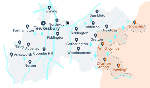
- This grey map is just a guide. To view all stops, please see list below.
- The circle symbol (Tewkesbury town) indicates that the Robin will not complete journeys within the town centre (you can book a drop off there, coming in from outside town, or book a pick up from in town, and head out).
- All Robin areas are separate
- Our Tewkesbury District area overlaps into The Robin North Cotswolds (to the east), see the orange area. This is to allow residents in these overlapping areas to choose their preferred Robin service, and not designed for onward travel into a second Robin area. You should use you Robin booking to connect with a fixed line service, or get to your destination if no fixed line is available. See all fixed line services at TravelineSW.
- To travel from one Robin area into another, you would need two bookings and need to change vehicle.
Below is the full list of bus stops where you can be collected or dropped off, within the Tewkesbury District area of The Robin.
- For the interactive map, and to book a journey, please log into the website
- Use our App (download on Apple or Android)
- If neither of these are possible, please call our Robin team: 0345 263 8139 📱
Stop name |
Village / District |
|
Cambridge Square (N), Cambridge Square, Alderton |
Alderton |
|
Cambridge Square (SE), Cambridge Square, Alderton |
Alderton |
|
Bus Shelter (E), Teddington Road, Alstone |
Alstone |
|
Bus Shelter (W), Teddington Road, Alstone |
Alstone |
|
Village Hall (E), Sawpit Lane, Apperley |
Apperley |
|
Village Hall (W), Sawpit Lane, Apperley |
Apperley |
|
Westview (S), School Road, Apperley |
Apperley |
|
Westview (N), School Road, Apperley |
Apperley |
|
War Memorial (S), Apperley |
Apperley |
|
War Memorial (N), Apperley |
Apperley |
|
Fitzhamon Park (W), Tewkesbury Road A46, Ashchurch |
Ashchurch |
|
Fitzhamon Park (E), Tewkesbury Road A46, Ashchurch |
Ashchurch |
|
Dobbies Ashchurch (S), Diamond Road, Ashchurch |
Ashchurch |
|
Dobbies Ashchurch (N), Diamond Road, Ashchurch |
Ashchurch |
|
Morrisons (NW) |
Ashchurch Rd |
|
Morrisons (SE) |
Ashchurch Road |
|
Memorial Hall (SE), Nup End, Ashleworth |
Ashleworth |
|
Primary School (NE), The Green, Ashleworth |
Ashleworth |
|
Primary School (SW), Main Street, Ashleworth |
Ashleworth |
|
Queen's Head Inn (NW), B4079, Aston Cross |
Aston Cross |
|
Queen's Head Inn (SE), B4079, Aston Cross |
Aston Cross |
|
Ashchurch Camp (SW), A46, Aston Cross |
Aston Cross |
|
Ashchurch Camp (NE), Aston Cross |
Aston Cross |
|
Dundry Nurseries (E), Bamfurlong Lane, Bamfurlong |
Bamfurlong |
|
Dundry Nurseries (W), Bamfurlong Lane, Bamfurlong |
Bamfurlong |
|
Stoke Road (N), Bypass A435, Bishops Cleeve |
Bishops Cleeve |
|
Stoke Road (S), Bypass A435, Bishops Cleeve |
Bishops Cleeve |
|
Swanbrook Transport Ltd |
Cheltenham |
|
Hare & Hounds (SW), Cheltenham Road East, Churchdown |
Churchdown |
|
Hare & Hounds (NE), Cheltenham Road East, Churchdown |
Churchdown |
|
Rising Sun Hotel (SW), B4632, Cleeve Hill |
Cleeve Hill |
|
Rising Sun Hotel (NE), B4632, Cleeve Hill |
Cleeve Hill |
|
Stockwell Lane (SW), B4632, Cleeve Hill |
Cleeve Hill |
|
Stockwell Lane (NE), B4632, Cleeve Hill |
Cleeve Hill |
|
Malvern View (SW), B4632, Cleeve Hill |
Cleeve Hill |
|
Malvern View (NE), B4632, Cleeve Hill |
Cleeve Hill |
|
Swan Inn (S), Coombe Hill |
Coombe Hill |
|
Swan Inn (N), Coombe Hill |
Coombe Hill |
|
Bank Farm Turn (S), Dumbleton |
Dumbleton |
|
Bank Farm Turn (N), Dumbleton |
Dumbleton |
|
St Peter's Church (NW), Dumbleton |
Dumbleton |
|
St Peter's Church (SE), Dumbleton |
Dumbleton |
|
Blacksmiths Lane (N), Dumbleton |
Dumbleton |
|
Blacksmiths Lane (S), Dumbleton |
Dumbleton |
|
Lowdilow Lane Junction (SW), Lowdilow Lane, Elmstone Hardwicke |
Elmstone Hardwicke |
|
Quarry Crossroads (SE), B4077, Ford |
Ford |
|
Quarry Crossroads (NW), B4077, Ford |
Ford |
|
Memorial (W), Gretton Road, Gotherington |
Gotherington |
|
Memorial (SE), Gretton Road, Gotherington |
Gotherington |
|
The Shutter (W), Malleson Road, Gotherington |
Gotherington |
|
The Shutter (E), Malleson Road, Gotherington |
Gotherington |
|
Post Office (SW), Cleeve Road, Gotherington |
Gotherington |
|
Post Office (NE), Cleeve Road, Gotherington |
Gotherington |
|
Church Lane (N), Great Washbourne |
Great Washbourne |
|
Church Lane (S), Great Washbourne |
Great Washbourne |
|
Becketts Lane (NW), Evesham Road, Greet |
Greet |
|
Becketts Lane (SE), Evesham Road, Greet |
Greet |
|
The Pines (E), Becketts Lane, Greet |
Greet |
|
The Pines (W), Becketts Lane, Greet |
Greet |
|
Working Lane (SE), Gretton Road, Gretton |
Gretton |
|
Working Lane (NW), Gretton Road, Gretton |
Gretton |
|
Stanley Cottages (NE), Gretton Road, Gretton |
Gretton |
|
Stanley Cottages (SW), Gretton Road, Gretton |
Gretton |
|
Gilders Yard (S), Gretton Road, Gretton Fields |
Gretton Fields |
|
Gilders Yard (N), Gretton Road, Gretton Fields |
Gretton Fields |
|
Hawling Lodge (SE), Guiting Road, Hawling |
Hawling |
|
Hawling Lodge (NW), Guiting Road, Hawling |
Hawling |
|
Methodist Church (SW), Main Street, Hawling |
Hawling |
|
Methodist Church (E), Main Street, Hawling |
Hawling |
|
Imjin Barracks (E), Innsworth Lane, Innsworth |
Innsworth |
|
Imjin Barracks (W), Innsworth Lane, Innsworth |
Innsworth |
|
Laverton Village (S), Main Street, Laverton |
Laverton |
|
Laverton Village (N), Main Street, Laverton |
Laverton |
|
The Hobnails (SE), B4077, Little Washbourne |
Little Washbourne |
|
The Hobnails (NW), B4077, Little Washbourne |
Little Washbourne |
|
Wainlode Lane (E), B4213, Lower Apperley |
Lower Apperley |
|
Wainlode Lane (W), B4213, Lower Apperley |
Lower Apperley |
|
Manor Primary School (SW), Carrant Road, Mitton |
Mitton |
|
Digby Drive (SW), Arundel Road, Mitton |
Mitton |
|
Business Centre (S), Shannon Way, Newtown |
Newtown |
|
Business Centre (N), Shannon Way, Newtown |
Newtown |
|
Tewkesbury School (W), Ashchurch Road, Newtown |
Newtown |
|
Tewkesbury School (E), Ashchurch Road, Newtown |
Newtown |
|
Long Eights (N), The Park, Northway |
Northway |
|
Long Eights (S), The Park, Northway |
Northway |
|
Northway Trading Estate (SW), Northway Lane, Northway |
Northway |
|
Northway Trading Estate (NE), Northway Lane, Northway |
Northway |
|
King's Head (NE), Old Road, Norton |
Norton |
|
King's Head (SW), Old Road, Norton |
Norton |
|
Caravan Park (N), Norton |
Norton |
|
Caravan Park (S), Norton |
Norton |
|
Westfield (E), Stanborough Lane, Notgrove |
Notgrove |
|
Westfield (W), Notgrove |
Notgrove |
|
Oxenton Turn (S) |
Oxenton |
|
Oxenton Turn (N) |
Oxenton, Tewkesbury |
|
Ellendene Drive (NW), Pamington Lane, Pamington |
Pamington |
|
Ellendene Drive (SE), Pamington Lane, Pamington |
Pamington |
|
The White House (SE), Sandhurst Lane, Sandhurst |
Sandhurst |
|
The White House (NW), Sandhurst Lane, Sandhurst |
Sandhurst |
|
Hill View (NE), Sandhurst Lane, Sandhurst |
Sandhurst |
|
Hill View (SW), Sandhurst Lane, Sandhurst |
Sandhurst |
|
St Lawrence's Church (SE), Sandhurst |
Sandhurst |
|
St Lawrence's Church (NW), Sandhurst |
Sandhurst |
|
Crown Inn (S), A38, Shuthonger |
Shuthonger |
|
Crown Inn (N), A38, Shuthonger |
Shuthonger |
|
Church End (Triangle) |
Shutonger Lane |
|
Stanton North Turn (NE), B4632, Stanton |
Stanton |
|
Stanton North Turn (SW), B4632, Stanton |
Stanton |
|
Stanton West Turn (SW), B4632, Stanton |
Stanton |
|
Stanton West Turn (NE), B4632, Stanton |
Stanton |
|
Cotswold Manor (SE), Stratford Bridge |
Stratford Bridge |
|
Village Hall (SE), Main Street, Teddington |
Teddington |
|
Village Hall (NW), Main Street, Teddington |
Teddington |
|
Teddington Hands Garage (SW), Teddington Hands |
Teddington Hands |
|
Teddington Hands Garage (NE), Teddington Hands |
Teddington Hands |
|
Boots (SW), High Street, Tewkesbury |
Tewkesbury |
|
The Crescent (SW), Tewkesbury |
Tewkesbury |
|
Hospital (W), Barton Road, Tewkesbury |
Tewkesbury |
|
Hospital (E), Barton Street, Tewkesbury |
Tewkesbury |
|
Tewkesbury Council Offices |
Tewkesbury |
|
Church Lane (SW), Gloucester Road, The Leigh |
The Leigh |
|
Church Lane (NE), Gloucester Road, The Leigh |
The Leigh |
|
Josend Crescent (NW), B4213, Tirley |
Tirley |
|
Josend Crescent (SE), B4213, Tirley |
Tirley |
|
Church Lane (NW), Tewkesbury Road B4077, Toddington |
Toddington |
|
Church Lane (SE), Tewkesbury Road B4077, Toddington |
Toddington |
|
Odessa Inn (N), Gloucester Road, Tredington |
Tredington |
|
Odessa Inn (S), Gloucester Road, Tredington |
Tredington |
|
Tredington School (SE), Stoke Road, Tredington |
Tredington |
|
Tredington School (NW), Stoke Road, Tredington |
Tredington |
|
Orchard Park (NE), A38, Twigworth |
Twigworth |
|
Orchard Park (SW), A38, Twigworth |
Twigworth |
|
Village Store (NW), High Street, Twyning |
Twyning |
|
Village Store (SE), High Street, Twyning |
Twyning |
|
Cotswold Grange Country Park |
Twyning |
|
The Mayalls / Goodiers Lane |
Twyning |
|
The Plant Centre (NW), Tewkesbury Road, Uckington |
Uckington |
|
The Plant Centre (SE), Tewkesbury Road, Uckington |
Uckington |
|
Greet Road (W), Kenelm Rise, Winchcombe |
Winchcombe |
|
Greet Road (E), Kenelm Rise, Winchcombe |
Winchcombe |
|
War Memorial (SW), Abbey Terrace, Winchcombe |
Winchcombe |
|
War Memorial (NE), Abbey Terrace, Winchcombe |
Winchcombe |
|
Medical Centre (N), Greet Road, Winchcombe |
Winchcombe |
|
Britannia Way (W), Two Hedges Road, Woodmancote |
Woodmancote |
|
Britannia Way (E), Two Hedges Road, Woodmancote |
Woodmancote |
|
St Catherine's Church (E), Wormington |
Wormington |
|
St Catherine's Church (W), Wormington |
Wormington |
|
Three Ways North (N), Aston Somerville Road, Wormington |
Wormington |
|
Three Ways South (S), Aston Somerville Road, Wormington |
Wormington |
As mentioned above, no journeys can be booked wholly within Tewkesbury town centre. This is because walking routes and fixed line bus services are already available.
Last reviewed: